-
photos/banner_1.jpg

-
photos/banner_2.jpg
-
photos/banner_3.jpg
-
photos/banner_4.jpg
HOME > PROJECTS > INFRASTRUCTURE
Infrastructure
INFRASTRUCTURE IN URUGUAY
Uruguay has a strategic geographical location and an adequate infrastructure in continuous expansion; it is in an optimal position for the development of transport of passengers and goods by sea, air and land.
Located in the 2nd place in South America in infrastructure development with deep-water ports, airports and the densest highway network in Latin America, any product produced in Uruguay can be transported to different parts of the world, mainly to other development areas in South America in short times.
The country has the 2nd place in power supply quality, with extensive cover throughout the country in telecommunication services.
The country has the 2nd place in power supply quality, with extensive cover throughout the country in telecommunication services.
INFRASTRUCTURE NEAR THE PROJECT
ENERGY
MEDIUM DISTANCE FROM THE PROJECT TO A 500 kV LINE = 10 Kmts At present there are power lines of 150 kV up to Melo city, at an average of 9 kmts from the areas of study.
MEDIUM DISTANCE FROM THE PROJECT TO A 500 kV LINE = 10 Kmts At present there are power lines of 150 kV up to Melo city, at an average of 9 kmts from the areas of study.
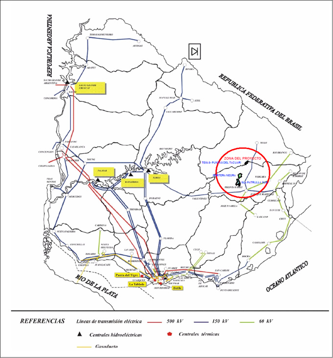
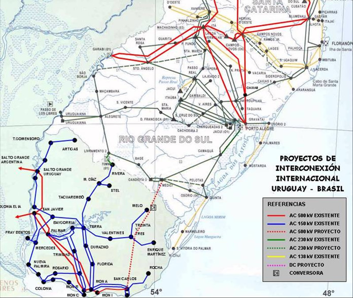
The interconnection line linking San Carlos Station 500 kV in Maldonado department, 50 Hz (Uruguay) and the area in the south of Brazil, where at present is President Medici station, (60 Hz) is under construction.
The project involves the laying of transmission lines, the expansion and construction of transformer stations and the installation of the frequency conversion station (500 MW, 50/60Hz).
The completion of works is scheduled for mid 2014. (See more in here)
The project involves the laying of transmission lines, the expansion and construction of transformer stations and the installation of the frequency conversion station (500 MW, 50/60Hz).
The completion of works is scheduled for mid 2014. (See more in here)
TRANSPORT
HIGHWAYS
MEDIUM DISTANCE FROM THE PROJECT TO THE INTERNATIONAL HIGHWAY = 15 Km of roads in good condition.
DISTANCES
From port of Montevideo = 300 kmts.
From Rio Grande do Sul = 200 kmts.
From Porto Alegre = 500 kmts.
The national highway network is one of the densest in Latin America. It has a development of 9,700 km., with an estimated patrimonial value of US$ 1,250,000,000.
The part of the network that corresponds to international operative corridors represents about 30% of the total area.
International highways in Uruguay were designed to contribute with regional integration processes. Their definition is the framework to create programs to adequate geometrically and structurally, highways and bridges to the new demands of international freight traffic. This is expected to reduce costs of freight transportation and improve accessibility to the most important national activity centers, increasing the competitiveness of
International highways with Brazil
- Highways 8 and 9, connecting the southern region with Brazil through Chuy.
- Highway 5, connecting the southern and central regions with Brazil through Rivera and Livramento.
- Highways 8, 17, 18 and 26, connecting the south and east with Brazil through Rio Branco - Yaguarón and the first highway.
International highways with Argentina
- Highway 1, connecting the south of the country with Argentina through Colonia, at present through the river bridge. This highway would increase its importance with the building of the bridge Colonia - Buenos Aires.
- Highways 3, 11, 23, 12 and 2, connecting the south-west of the country with Argentina through San Martin International Bridge and the previous highway.
- Highway 3, connecting the western region with Argentina through Gral Artigas International Bridge and previous highways.
Pavements condition and traffic capacity, culminating in border crossings varies from regular to good, given geometric design problems that still exist and marked deficiencies from art works.
The most obvious infrastructure deficit occurs in bridges located in the main transport inter-regional highways. This prevents the use of the fully loaded semi-trailer triple axle with twelve tires and semi-trailers of latest generation with three separate axles. In particular, semi-trailers with three axles of twelve tires now constitute 50% of the total capacity offered by the different transport companies operating in Uruguay trades with the rest of MERCOSUR.
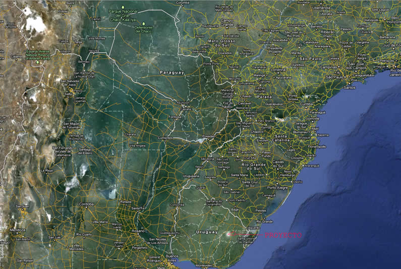
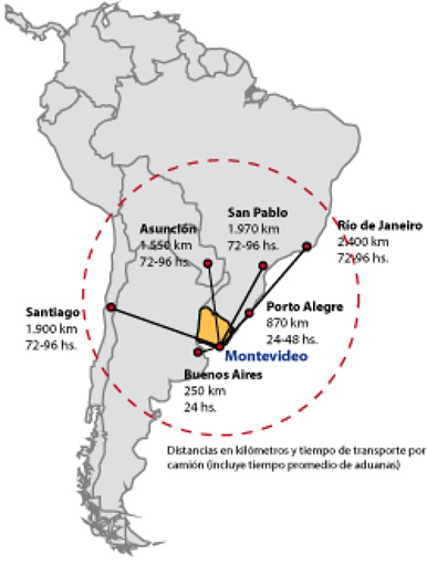
Map - Uruguay and connection routes to the region
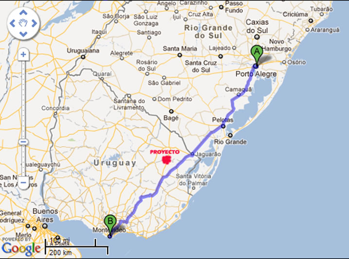
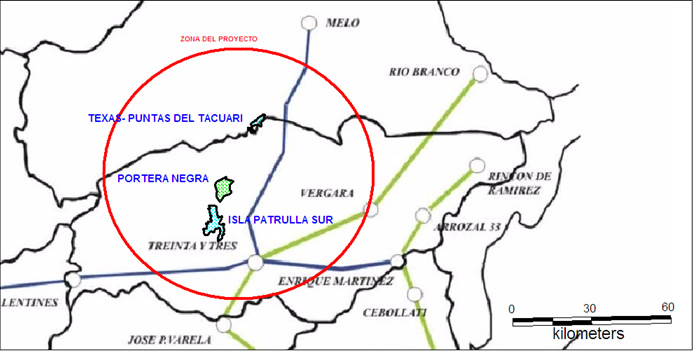
Map - Location of the project in the corridor Montevideo - Porto Alegre
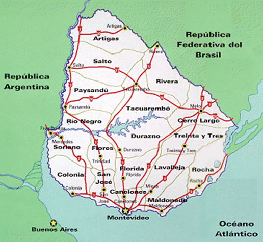
Map - Main Routes of Uruguay

Map - Road Infrastructure and topography of the project
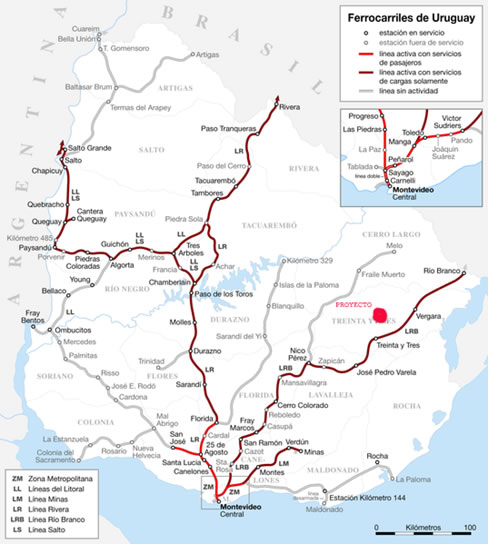
RAILWAYS
Loads leaving by rail from Uruguay have limited size. The working of the Uruguayan railway in Mercosur can not be considered independent from the regional rail network.
The railway network, managed by AFE, in terms of services and maintenance of track has 3,000 kmts of length, from which about 1000 km are out of operation for various reasons.
Networks that have a closer relationship with AFE system are railways from Mesopotamia Argentina and rail network RFFSA (Sul-Atlantic Railroad), from Brazil, specifically sub region 6 (SR6) corresponding to the South area.
AFE corridors with regional significance are:
a) Montevideo to Salto through Chamberlain
b) Tres Arboles-Rivera or Chamberlain-Rivera (connecting Rivera with Montevideo)
c) Montevideo-Rio Branco
AFE stations that communicate with the regional railways are Salto Grande and Rivera, in Salto, with the Mesopotamian Railway, the third corridor, through Rio Branco-Yaguarón, it has no rail connection in the Brazilian side and the station actually serves as transfer point for trucks. The maintenance condition of roads is the greatest weakness in Uruguay's system.
The railway system in Uruguay may in the future have a more important role than it has at present if it can take advantage of forest production and increase the internal demand of its services, justifying the improvement of railways. In this sense, an improvement program is considered for Montevideo-Rivera corridor.
Waterways
The river waterway systems serving the area of influence of the Uruguayan transport system are:
a) Paraguay-Paraná, distinguishing two parts in it according to their transport function, which are Paraguay-Parana project (Caceres, Nueva Palmira) and Alto Paraná system.
b) Uruguay River Waterway from Nueva Palmira to Salto.
c) Because of its competence relationship, the Tiete-Parana waterway.
Paraguay-Paraná waterway
The most important regional system is referred to the combination Paraguay-Parana river. Recent advances related to this project are the ratification of the Navigation agreement, which will give advantages to corridors that converge toward the River Plate versus terrestrial corridors leading to Brazilian ports.
Uruguay River
The second system, Uruguay River. At present it has economic importance up to Salto Grande dam (Km340). Two sections can be distinguished; the first up to Concepcion del Uruguay, capable of being navigated by oceanic vessels as it is dredging the river to that point, with a depth of 23 feet to zero, enabling 25 feet of effective draft. This allows the navigation of ships from overseas loaded with up to 60 or 70% of its capacity. The use upstream in the second section, is only possible through barges and deepening, according to previous studies, has little economic return. A recent binational agreement considers the deepening of navigation channels upstream Concepción del Uruguay.
The Uruguay River system is of great importance for the development of forestry in the country (very sensitive to transportation costs), for the highest percentage of plantations within the provinces bordered by Tietê-Paraná river.
Tieté-Paraná waterway
A third waterway system in the region is Tiete-Parana linking Porto Anhuma 200 kilometers from Sao Paulo to Sao Simao Dam. It has 1040 Km navigable in that area. The problems in that area are related to limitation of depth, inferior to 2.5 meters in many areas. This would mean a competition with the Paraguay-Paraná system, while it may reorient the flow from Paraguay, Brazil and Bolivia hinterland.
Regional port system
Ports in MERCOSUR countries have every time greater interdependence with the incorporation of multimodal schemes. The port situation in Lower Paraná and Rio de la Plata has had significant changes resulting from changes in the regulatory framework. Since the sanction of the Law of Ports in Argentina and Decree 817/92, from Uruguay's law of Ports (No. 16,246), the framework where ports operate in the region has changed considerably; this has impacted positively but not to the extent expected when creating the law.
In general, new legislation has enabled greater private sector participation in port operation and investment and has established some basic principles on rates and administrative pricing, which has caused greater productivity and cost reduction. Another impact is the specialization of terminals.
A second change is the development of projects to deepen access channels to the Atlantic.
Ports in Uruguay
Montevideo: the area of influence of this port is focused on foreign trade, cargo to Paraguay entering for the Waterway and in small-scale from the south of Brazil. It could significantly expand its area of influence.
Loading and unloading operation of the ship is carried out by stevedoring companies, but spring teams, the Containers Terminal and part of the storage are operated by ANP (the containers terminal is being transferred to a private operator by concession). Deregulation in ports has been partial so far.
The law is also clear regarding ports decentralization. ANP is responsible for the administration of ports in Colonia, Nueva Palmira and Fray Bentos.
Ports in Argentina
Buenos Aires: it focuses mainly on Argentinean loads and in those from Paraguay entering through the Waterway. This port has some natural disadvantages, which causes maintenance cost of its access channels, given their limited depth. Recent deregulations have increased productivity and decreased to some extent costs for users, tending to a strong specialization in cargo moved in containers. The remaining loads have been moving toward specialized ports in other parts of the country.
Overall, growth perspective in traffic in Uruguayan ports is based on the one hand, on the grain transport market, where it competes with Parana ports and on the other hand, on the movement of general cargo and containers where competence is basically with Buenos Aires. The main ports in the provinces in Argentina are: San Lorenzo / San Martin (it handles a volume of 9 million tons), Rosario, Lower Parana (San Nicolas, Zarate, Campana, San Pedro, Ramallo and Baradero). All these ports belonged to the General Administration of Ports in Argentina and now are part of Buenos Aires. The first four make up the Lower Paraná Port Delegation.
Ports in the South of Brazil
The area of influence of these ports is limited to the Brazilian territory, especially to the states of the Southeast, Midwest and South of Brazil. Also, loads from Paraguay, in particular, containers that access Ciudad del Este and grain exports from this country and from Santa Cruz de la Sierra Department, province of Bolivia. The activity of ports in Brazil is in deregulation process, Law No. 8630, Modernization of Brazilian Ports February 1993, promoting decentralization and other measures.
The main ports are Rio Grande (3.7 million tons in 1992) and Paranaguá.
Ports in Paraguay
It comprises a series of ports that serve Paraguay's foreign trade, the most important are: Asunción port (Asuncion and Villeta), accessed by loads entering the waterway from Buenos Aires and Montevideo, Ciudad del Este, with loads arriving from ports in Brazil, and Puerto Falcón, with loads from Argentina and Chile by land and foreign trade when it must be "deconsolidated" to pass through the customs.
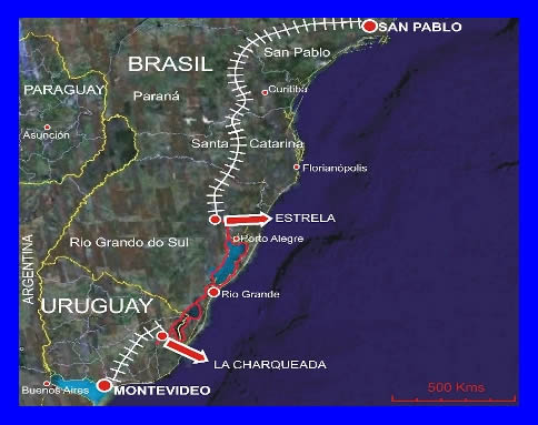
90 kmts from the project La Charqueada port is in an advanced stage.( http://www.puertocharqueada.com).
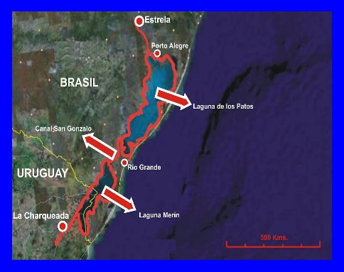
This port terminal will serve to export splintered wood in rolls, rice and industrial calcareous rock, constituting a basic traffic that will attract other loads from intraregional trade, linking the east of Uruguay with San Pablo, passing near Porto Alegre.
Home
Company
Projects
Responsibility
Uruguay Limestone © 2012. All rights reserved.