-
photos/banner_1.jpg

-
photos/banner_2.jpg
-
photos/banner_3.jpg
-
photos/banner_4.jpg
HOME > PROJECTS > OVERVIEW
Overview
INTRODUCTION
NOLETIR SA entered into an "option and farm agreement" with OROSUR MINING INC. (www.orosur.ca) to explore one or more deposits of limestone for cement and/or clinker and/or lime and/or ground correction and/or raw material for pig iron projects in Uruguay. .
An investment over USD 1,250,000 is considered for prospecting and exploration stages.
Orosur Mining Inc. is a gold production and exploration company established in Canada identifying and developing mining projects in South America. At present OMI exploits the only operative gold mine in Uruguay. It has a portfolio of important gold, diamonds, base metals, limestone exploration projects in Uruguay, Chile, Argentina and Brazil.
Orosur Mining Inc. owns the licenses of projects, technical reports and information related to the mining properties.
Noletir SA will carry out the final exploration and feasibility studies of commercial exploitation.
PROJECT DESCRIPTION
Limestone deposits studied cover an area exceeding 2,000 hectares of outcrops in a mining permits surface over 10,000 hectares.
REGIONAL GEOLOGY
The aforementioned mining permits are located in Terreno Nico Pérez (BOSSI & CAMPAL, 1991), covering a small area in the eastern border, mostly in Treinta y Tres Department, and in some areas in Cerro Largo Department. The eastern border corresponds to the significant "Cizalla de Sierra Ballena" (Sierra Ballena Shear) which separates the area of interest from deformed granitoids from "Terreno Cuchilla Dionisio". The western border corresponds to a less significant shear which limits the area of the western metamorphic complex (Figure 1). According to the Geological Map of Uruguay (2001, version 2.0), taken as base map for Figure 1, there is a strip of lighter color corresponding to rocks called "Grupo A° Del Soldado", intruded by a series of post-collisional granites.
Arroyo del Soldado Group (Gaucher et al., 1996) is a sequence of sedimentary rocks with low metamorphism. These sedimentary series from sandy to pelitic rocks have been part of ingressive episodes - regressive, of passive continental margin. In this package of sedimentary rocks there are significant amounts of metamorphic limestone in sub vertical dip banks, and variable tensions from depths of 50m to 200m.
Arroyo del Soldado Group (Gaucher et al., 1996) is a sequence of sedimentary rocks with low metamorphism. These sedimentary series from sandy to pelitic rocks have been part of ingressive episodes - regressive, of passive continental margin. In this package of sedimentary rocks there are significant amounts of metamorphic limestone in sub vertical dip banks, and variable tensions from depths of 50m to 200m.
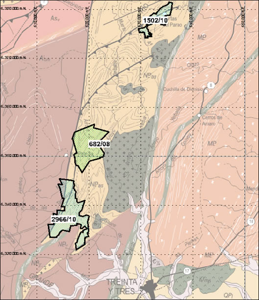
Figure 1 - Regional Geologic Background and projects Orosur MINING Inc.
OTHER COMPANIES IN THE AREA
Surrounding the areas of the projects there are multiple calcareous deposits defined by companies such as ANCAP, VOTORANTIM, CEMENTOS CIELO AZUL, and others.
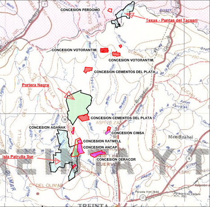
Figure - Other companies near OROSUR - NOLETIR SA projects.
VOTORANTIM, ANCAP and CEMENTOS ARTIGAS (Cemolins Internacional SL) have made an agreement to exploit and produce cement in the areas around Texas - Puntas del Tacuarí project (permit 1502/10) at a distance of 10 kmts between both. This project plans to produce 800,000 tons/year cement.
CEMENTOS CIELO AZUL (Deracor Concession) located at a distance of 5 kmts from ISLA PATRULLA SUR project (permit 2966/10) plans to produce 750,000 tons/year of cement.
ANCAP is located just 500m from ISLA PATRULLA SUR project (permit 2966/10) it is planning a lime plant with an investment of USD 40,000,000.
Projects:
TEXAS - PUNTAS DEL TACUARI PROJECT
The area is located in the northeast sector of Puntas del Yerbal photo plan (E-18), southeast of photo plan C° de las Cuentas (E-17), southwest of Arbolito photo plan (D-17) and northwest of Parao photo plan (D-18.) Access is from highway Number 8, kilometer 342, taking the minor road to the west. To access the area of study through the north-center area you cover about 24 kmts.
GK coordinates from the central area are: E 633500 - N 6378400. The area affected by the permit involved (1502/10) is of 1410 hectares, corresponding mostly to the 4th Judicial Division and cadastral department from Treinta y Tres and a smaller proportion to the 10th division of Cerro Largo Department. Figure 3 shows the location and access to the area in the aforementioned 1:50.000 scales. They correspond to Uruguay's National Cartographic Plan created by the Military Geographic Service of that country.
GK coordinates from the central area are: E 633500 - N 6378400. The area affected by the permit involved (1502/10) is of 1410 hectares, corresponding mostly to the 4th Judicial Division and cadastral department from Treinta y Tres and a smaller proportion to the 10th division of Cerro Largo Department. Figure 3 shows the location and access to the area in the aforementioned 1:50.000 scales. They correspond to Uruguay's National Cartographic Plan created by the Military Geographic Service of that country.
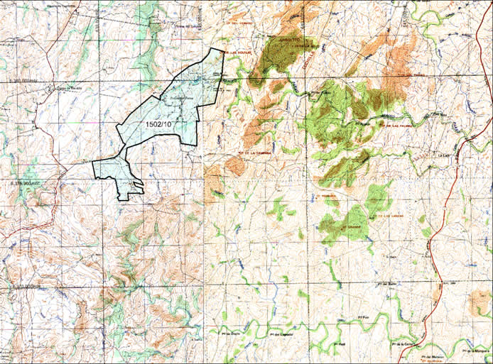
Localización Proyecto Texas/Puntas del Tacuarí
(Sistema de Coordenadas: Elipsoide Hayford, 1924; Proyección: Gauss; Datum: Yacaré)
Predominant lithologies are pelites and siltites in all the area, affected by low to medium grade metamorphism. Secondly, limestone, shown in Figure 4, dark gray-blue to light gray, of fine grain, with silica impurities in centimeter horizons. From the point of view of texture these limestones have fine granulometry; medium to high purity with banded composition defined by color changes and well defined stratification. Banding is given by millimeter plates rich in quartz, immerse in centimeter bands of carbonate. Locally, they are gently folded and alternated with metasandstones.
A fracture with NS and N45E direction has a moderate expression, probably returning to old directions of infrastructure basement foliation observed a few kilometers to the west of the area studied.
A fracture with NS and N45E direction has a moderate expression, probably returning to old directions of infrastructure basement foliation observed a few kilometers to the west of the area studied.
PORTERA NEGRA PROJECT
This project is located largely within the north-center area of Isla Patrulla photo plan (E-19). It is accessed through highway No. 8, kilometer 307, taking the minor road to the west. You cover about 14 km to access the area of study through the east-center area.
GK coordinates from the central area are: E 620300 - N 6352800. The area affected by the permit involved (tenement 682/08) is of 3995 hectares, corresponding to the 4 th and 5 th Judicial and Cadastral Division from Treinta y Tres Department. Figure 5 shows the location and access to the area in the aforementioned 1:50,000 scales, corresponding to Uruguay's National Cartographic Plan prepared by the Military Geographic Service from that country.
The area topography is undulating to strongly uneven with low coverage of soils and medium to high density of outcrops. The use of the land is mainly for livestock.
A set of metamorphic lithologies and ortho-derivative for low grade, deformed and folded were defined in the area studied which according to their gradation would form part of a proximal type platform sequence.
Carbonated rocks, limestones sequences, are widespread as can be seen in Figure 6. They have very fine grain, with dark-blue colours, and equigranular texture. Compositional banding is marked with color changes and millimeter film layers rich in quartz-rich, embedded in carbonate bands every 2 to 5cm. There is occasional presence of oolitic type structures, which reveal its sedimentary origin.
All rock sequences present a medium grade metamorphism. The predominant fault continues to be N45 and dips are generally vertical to sub vertical in calcareous packages. Sometimes it is common to find gray limestones with medium and coarse grain, well bedded, alternating brownish limestones intensely folded, with dips of 30 ° to 40 ° with northwest direction. Sometimes metamorphic schists with tensions of 50 cm alternate which lowers dips to 25 ° approximately.
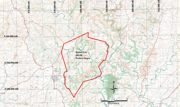
Figure 5 - Location Portera Negra Project
(Coordinate System: Elipsoide Hayford, 1924; Projection: Gauss; Datum: Yacaré)
ISLA PATRULLA SUR PROJECT
Isla Patrulla Sur Project, at a distance in straight line of about 25 km northwest of Treinta y Tres city is the closest to the locality of the 3 projects presented in this report. Most of the area is located in the south-center area of Isla Patrulla photo plan (E-19), and a small area to the south of the permit corresponds to the north-center area from Treinta y Tres photo plan (E-20). Access is through Treinta y Tres city taking highway 98 with northwest direction and you enter the area of study in kilometer 21.
GK coordinates from the central area are: E 616100 - N 6337900. The area affected by the permit involved (Tenement 2966/10) is of 4900 hectares, corresponding to the 1 st and 5 th Judicial and Cadastral Division from Treinta y Tres Department. Figure 7 shows the location and access to the area in the aforementioned 1:50,000 scales corresponding to the National Cartographic Plan created by the Military Geographical Service.
Topography of the area is rough, with sedimentary sequences of rocks ortho-derivates, with low grade, deformed, covering almost the entire area of study, highly folded and deformed.
Sequences of limestone rocks have N30-N45 direction, sub vertical dip to the northwest. These packages show tension in depth.
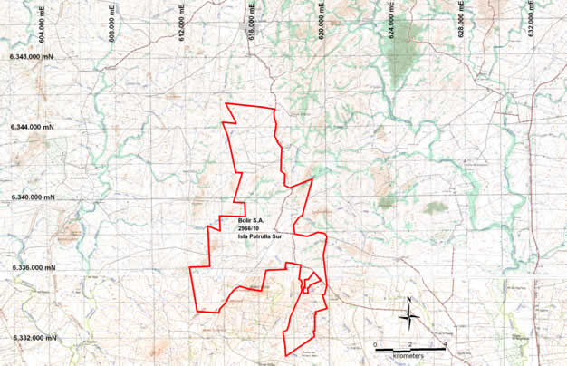
Location Isla Patrulla Sur Project
(Coordinate System: Elipsoide Hayford, 1924; Projection: Gauss; Datum: Yacaré)
Fine-grained limestones are dark gray, with equigranular granoblastic texture, and some impurities. Folds of metric tensions were observed with presence of metallic material in hinge areas and locally levels rich in silica up to 10 cm. They show characteristics of ductile-ruptile deformation where there if flow of less competent portions with brecciation / boudinage of more competent portions. They show calcite in millimeter veinlets. Generally they show scarse dolomitic levels.
Home
Company
Projects
Responsibility
Uruguay Limestone © 2012. All rights reserved.